Kyle Walker, Ph.D., director for the Center for Urban Studies and an associate professor of geography, has loved maps ever since he was a child. Today, he uses maps, data visualization and geographic information systems (GIS) to help solve societal and organizational problems.
Walker specializes in the study of demographic trends in U.S. metropolitan areas, and his recent research projects have addressed generational trends in U.S. internal migration, shifts in neighborhood racial diversity in cities and suburbs, and demographic data visualization.
Read More
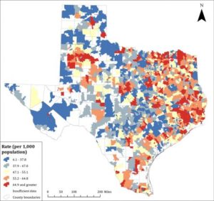
Texas Heart Disease Hospitalization by ZIP Code: Kyle Walker and Sean Crotty’s geographic distribution of age-adjusted hospitalization rates from 2006 shows high rates (red shades) in East and Northeast Texas, the Rio Grande Valley and West Texas, while lower rates (blue shades) are found in parts of Central and Northwest Texas. Courtesy of TCU Magazine.
- A Deficit of Care: Needs Assessment in the Las Vegas Trail Community of Fort Worth, Texas
- The Geography of Heart Disease